Home >> Projects >> U.S. 61 >> Modern Highway Photo Galleries
 Modern Highway Photos: La Crosse to Winona
October, 2007 (Page 7)
>> Jump to Page: 1 | 2 | 3 | 4 | 5 | 6 | 7 | 8 | 9 | 10

Route markers on the north side of La Moille.

Looking north at a wayside rest just north of La Moille. According to construction
plans a small rest area was originally constructed here in 1938, with a stone
retaining wall and a spring outlet. The structures were apparently destroyed
when the highway was upgraded to four lanes in 1958.

Interpretive signage for the Upper Mississippi River National Wildlife and
Fish Refuge at the roadside rest area just north of La Moille, looking southeast
across the Mississippi towards Wisconsin. The refuge was created on June 7,
1924 by President Coolidge. It was the brainchild of Will Dilg, a founder
of the Izaac Walton League. Land for the refuge was purchased by the federal
government throughout the 1920's at the same time that the Department of Highways
was constructing the first modern highway used by U.S. 61 through the Mississippi
River valley. (Source: Anfinson, John O. "The River We Have Wrought
- A History of the Upper Mississippi", University of Minnesota Press,
2003).

More scenery on the highway between La Moille and Homer. This stretch of road
is on its fourth generation. The previous two-lane concrete road completed
in 1929 was preceded by a 8-foot wide concrete road, completed in 1913/1914,
which itself was preceded by at least one earlier primitive road.

At the junction with County Road 9, just north of Cedar Creek.

Approaching the entrance to the Pla-Mor Campground, a former KOA (note the
blue sign on the right). The two roads visible on the left are Woodland Hills
Drive and Little Smokies Lane.


Route markers at the town of Homer. U.S. 61 once traveled directly down Homer's
main street. When the highway was upgraded to four lanes in 1958, Homer was
bypassed, and a series of crib walls were constructed to keep the town from
sliding onto the new highway. The old two lane road between Homer and Winona
still exists, now marked as parts of County Roads 15, 17, and State Highway
43 (for more info, see the lost highway article here).

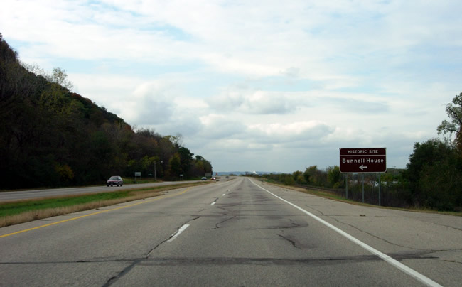
Looking north towards Winona on the north side of Homer. Note the sign for
the Bunnell House historic site.

The view of the modern highway, looking north from the parking lot of the
Bunnell House. A set of plans from 1961 show that a roadside parking area
was to be constructed in the empty field in the foreground. The plans never
came to fruition.

Another view to the north from the parking lot.

Now that I've mentioned the Bunnell House several times, I might as well include
a photo of it. U.S. 61's old alignment between Homer and Winona (County Road
15) is visible on the right, showing how much more accessible the house once
was to travelers on U.S. 61.
>> Next Page
>> Page Index
- Page 1 - Southbound on I-90
- Page 2 - Southbound, La Crescent and the Jct. with State Hwy. 16
- Page 3 - Southbound, From La Crescent to the Wisconsin State Line
- Page 4 - Northbound, From the Wisconsin State Line to La Crescent
- Page 5 - Northbound, At the South Jct. with I-90 Near Dresbach
- Page 6 - Northbound, From Dakota to La Moille
- Page 7 - Northbound, From La Moille to Homer
- Page 8 - Northbound, From Homer to the Jct. with State Hwy. 43 at Winona
- Page 9 - At Winona, From the Jct. with State Hwy. 43 to Gilmore Avenue
- Page 10 - From the Jct. with U.S. 14 at Winona to County Road 32 at Goodview
>> Back to the Photo Gallery Index
>> back to top
