 Historic U.S. 61: Old 2-Lane Alignment in the Winona Area

Above, a simplified map of the old 2-lane alignment through the Winona Area (the red line), showing the county and state routes on the old road today.
Old 2-Lane Alignment in the Winona Area
Located In (north to south): Rollingstone Township, City of Goodview, City of Winona, Homer Township, Winona County
Bypassed: 1957 / 58
Length: 11.04 miles
Also Marked As:
 1933-1957/58**, 1926-1929*
 Until 1934
 1921-1929*
 1934-Present ***
* On Gilmore Ave between Villa St and Junction Ave.
**East of Junction Ave
***Jct. Co Rd 17 to Jct. Co Rd 32
Inset 1: North End of County Road 32
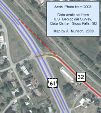
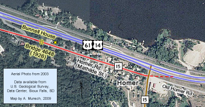
U.S. 61's old two-lane alignment in the Winona area stretches for about 11 miles between a point just southeast of Minnesota City on the west, and Homer on the east. The road begins as County Road 32 (see inset 1 below), running east through Goodview into Winona, where it becomes State Highway 43 at Main Street. Highway 43 then follows the old route to County Road 17 at the Sugar Loaf. County Road 17 occupies the road for only a short distance, until it too gives way to County Road 15 at St. Mary's Cemetery. County Road 15 then occupies the rest of the old road east to Homer. The road ends at County Road 15's connection to U.S. 61/U.S. 14 (see inset 2, below).
Inset 2: County Road 15 at Homer
Construction
The old road had a surprisingly complex construction history. It was constructed in a series projects spanning the decade between 1926 and 1936. The basic timeline is as follows (see overview map above for project end-points, marked with black boxes):
- Unknown Date - Paving of Mankato Avenue in Winona with brick.
- 1913/1914 - Construction of an 8-foot wide concrete highway between Pleasant Valley Creek and Homer (along County Road 15).
- 1926 - Two sections graded and paved with concrete, 18 feet wide: One along what is now County Road 15 between St Mary's Cemetery (near the Sugarloaf) and Pleasant Valley Creek, and another much longer portion along what is now County Road 32 through Goodview to Broadway (6th Street) in Winona.
- 1927- Regrading of the 8-foot concrete road between Pleasant Valley Creek and Homer. Surfaced temporarily with gravel.
- 1929 - Grading and paving with concrete on what are now Junction Avenue (south of Broadway), Gilmore Avenue, and Sarnia Street. Also the grading and paving of the road between St. Mary's Cemetery and the modern junction with Highway 43 (the section now occupied by State Highway 43 and County Road 17). Lastly, the grade constructed in 1927 to Homer is paved with concrete.
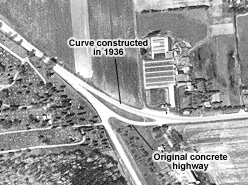
- 1936 - Final completion of the highway in the Winona area. The curve at the junction of County Roads 15 and 17 is rebuilt to lessen its severity. The last remaining brick pavement on Mankato Avenue between modern U.S. 61 and Sarnia Street is paved over with 40 feet of concrete.
Bypass History
The old road was bypassed by the construction of the modern four-lane highway between 1957 and 1958 (construction records indicate that the road west of Highway 43 was completed in 1957, and the road east of the junction in1958). The new road was built to bypass Winona by going around the south side of Lake Winona. The majority of the old road was turned over to Winona County. However, one section remained in the trunk highway system as part of State Highway 43.
Inset 3: Divided Roads and Transitions, West Winona

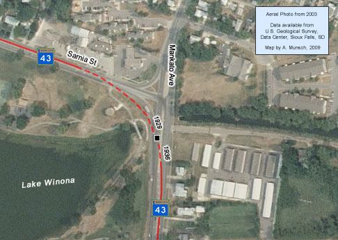
Inset 4: Intersection of Sarnia Street and Mankato Avenue, Winona
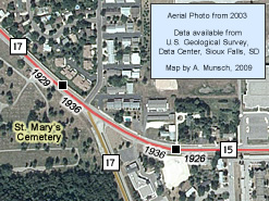
Inset 5: Junction of County Roads 17 and 15 at St. Mary's Cemetery
Current Status
As already mentioned, the old road is now mostly under county jurisdiction. The entire route has long since been repaved. Sadly, only County Road 15 (Homer Road) southeast of Winona has managed to retain most of its historic feel. This stretch contains two historic concrete bridges constructed in 1926/27 (bridges 4648 and 4649).
Several sections in Winona have been heavily rebuilt, including two sections upgraded into divided highways on the west end of town on Gilmore Avenue/Sarnia Street (see inset 3, above right). Interestingly, these divided sections are only one lane in each direction.
Also of interest is the intersection of Sarnia Street and Mankato Avenue at the northeast outlet of Lake Winona. In earlier days, the intersection was built with a curve to allow traffic on U.S. 61 to flow continuously between the two streets. The intersection was heavily rebuilt in 1977 into a normal T-intersection (see inset 4, right).
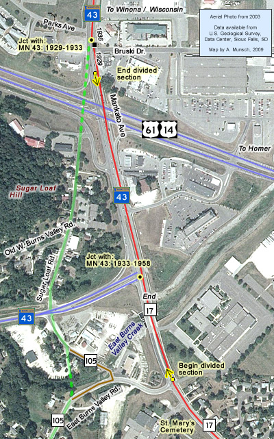
The section now occupied by Highway 43 on Mankato Avenue near the junction with modern U.S. 61/U.S. 14 is probably the most modern and up-to-date. It now services one of Winona's busiest retail districts.The stretch from just north of the modern highway to East Burns Valley Road was upgraded into a divided highway in about 1981 (see inset 8).
The junction of County Roads 17 and 15 at St. Mary's Cemetery has been thoroughly modernized (see inset 5, below right). Note the comparison of the junction today (left), with how it looked in 1956 (right). Reconstruction of the curve at the junction in 1936 resulted in a small stretch of original concrete road (from 1926) being left behind. Further modernization has wiped out any sign of the original pavement.
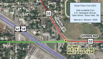
Inset 6: Historic Junction with U.S. 14 / MN 7
Historic Junction with:  1929-1957, and
  1929-1934
The intersection of Junction Street and Gilmore Avenue was the site of the historic north junction with U.S. 14 from 1929 to 1957, as well as Constitutional Route 7 from 1929 to 1934. This was also U.S. 14's and Highway 7's eastern terminus from 1929 to 1933. The junction itself has been heavily rebuilt since being bypassed.
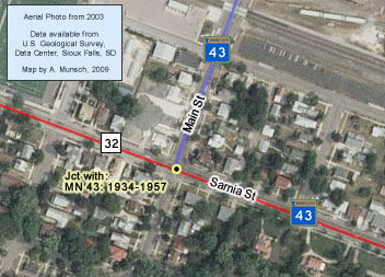
Inset 7: Junction of Highway 43 and County Road 32, Winona
Historic North Junction with:  1934-1957
The intersection of Main and Sarnia Streets was once the site of the north junction with State Highway 43 (it is now the junction of Highway 43 with County Road 32).
Highway 43, first marked in 1921, had originally terminated at its south junction with U.S. 61 near the Sugar Loaf. In 1934, it was extended north to the bridge to Wisconsin as part of a trunk highway system expansion.
Highway 43 still remains on the portion of the route it shared with U.S. 61 today.
Inset 8: Highway 43 at Modern U.S. 61/U.S. 14
Historic South Junctions with: 
 1929-1933 (Near Bruski Drive)
 1933-1958 (Modern Jct. of Hwy 43 and Co Rd 17)
The historic south junction with Highway 43 was located at two locations on the old two-lane road. The junction from 1929 to 1933 was just north of modern U.S. 61 on Mankato Avenue near Bruski Drive. At that point in time, Highway 43 was still using the East Burns Valley Road to enter Winona. In 1933, its permanent alignment through the West Burns Valley was built, and the junction was moved to what is now Highway 43's turn-off from the Homer Road at the junction with County Road 17.


