
 Historic U.S. 61: Old Highway 61 Between Illgen City and Little Marais
Old Highway 61 Between Illgen City and Little Marais
Located: from 1.25 miles north, to 2.25 miles north of the jct with State Hwy 1 along the east side of State Highway 61. In Beaver Bay Township, Lake County.

Historic Context: Part of the original North Shore Scenic Highway constructed in the 1920's.
Length: Approx. 1 mile total.
Constructed: 1924.
Bypassed: 1969, by construction of a new alignment.
Also Part Of:
Status: 0.29 miles open to traffic as a local road (marked as Old Hwy 61). 0.38 miles closed to traffic with final pavement left intact (on private property). 0.37 miles in use as private driveways.
Access: Public portion accessible directly from Highway 61, 1.25 miles north of Hwy 1 on the east side of the highway.
Old Kennedy Creek Bridge
Bridge #: 3460
Design: 80' steel truss. 20' wide roadway.
Constructed: 1923
Historic Context: Bridge built for the original North Shore Scenic Highway constructed in the 1920's.
Status: Demolished.
More U.S. 61 Articles
North >> Cross River Bridge
South >> Old Alignment at Illgen City

A one mile length of the original North Shore Scenic Highway survives between Illgen City and Little Marais along the east side of Highway 61. Sadly, it is now mostly closed to the public and is in use as a series of private driveways. Oblique photos taken by the DNR reveal that the road closely hugs the cliffs above Lake Superior, providing views now lost to the public. The road was bypassed in 1969 to eliminate several hair-pin turns, and replace the old bridge over Kennedy Creek (a short steel truss bridge, now lost).
Map
Key
- Green = Intact, open.
- Pale Green = Intact, private drive.
- Red = Ruin, pavement intact, closed.
- Orange = Old alignment, removed.
Photos - taken in April, 2010.

The turn-off onto Old Hwy 61, 1.25 miles north of Illgen City (photo looking northbound).

Closer view of the "Old Hwy 61" street sign.

The public portion of the old highway dead-ends at boulders, placed to prevent cars from driving onto private property. Also note how the old road appears to be in use as a pavement paint testing area.

If you look closely, you can see the old highway at the bottom of the embankment on the right.
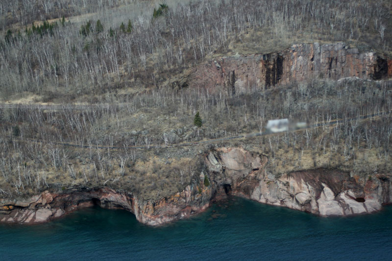
Oblique photo taken by the DNR in April, 2006, showing why the road is now closed off - someone has placed a house directly on the old road!! Note the house's placement directly below the rock-cut, which hides it from traffic on the current highway. If you look closely, you can also see an old metal guard rail
on the left side of the photo.
Sources
- MNDOT. Construction Project Log: Control Section 3808
- Minnesota Highway Department. Construction Plan for Trunk Hwy No. 61-1 Between Little Marais and Two Harbors: S.P. 61=1-01, June, 1923.
- Minnesota Highway Department. Construction Plan for Trunk Hwy 61, S.P. 3808-17. 1967.