 Historic U.S. 61: Plum and 7th Streets, Red Wing

Plum and 7th Streets
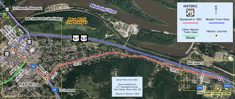
Located In: City of Red Wing, Goodhue County.
Bypassed: 1963
Length: 1.85 miles
Also Marked As:
 1935-Present*
 Until 1934
 1963-Present, 1934-1935**
 1963-Present***
*U.S. 63 on entire old alignment, 1935-1960. On 7th St and Plum St south of 3rd St, 1960-1963. On Plum from Main to 3rd St only, 1963-Present.
** T.H. 58 on Plum St only, 1934-1935 and 1963-Present.
*** T.H. 292 on the eastern end only.
U.S. 61's original route through the east side of Red Wing was along 7th and Plum Streets until the construction of the modern four-lane gateway along the foot of Barn Bluff in 1963.
Construction
7th and Plum Streets (south of 4th Street) were paved with 18 feet of concrete in 1924 as part of the construction of the first modern highway between Red Wing and Lake City. The city of Red Wing widened the pavement to the full extent of the streets at its own expense. The final two blocks on Plum between 4th and Main had been paved by the city with wood blocks on top of concrete at an unknown earlier date. The wood block was replaced by a modern concrete surface in 1939.
Bypass History
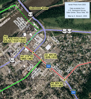
The old route through the east side of Red Wing wasn't bypassed until 1963, when the modern divided entrance to town along the foot of Barn Bluff was built. Plum Street was taken over by State Highway 58, plus U.S. 63 for the one block between Main and 3rd Streets. The very eastern end of 7th Street was taken over by State Highway 292, the state-maintained driveway between U.S. 61 and the State Training School.
Current Status
The original concrete pavements on 7th and Plum Streets were still intact when the old route into town was bypassed. All have long since been paved over (the concrete on Plum Street was paved over in 1965).
Inset 1

Inset 2

Photo Tour - Photos were taken in March, 2007.

Looking east at Main Street and Plum in downtown Red Wing, the modern junction
of U.S. 61 with U.S. Highway 63 and State Highway 58. Today, U.S. 61 continues straight
ahead with U.S. Highway 63 towards Lake City. U.S. 61 originally made a right
turn here onto Plum towards 7th Street. Notice Barn Bluff looming above the
highway ahead. This was the old junction with the route to the old wagon bridge across the Mississippi River, used by U.S. 63 (1935-1960), and Highway 58 (1934-1935).

Looking south on Plum Street at 3rd. This was the site of the north junction
with U.S. 63 from 1960 to 1963. U.S. 63 still turns off of Plum here onto
3rd Street to reach the the bridge to Wisconsin.

Looking south the at the intersection of Plum and 4th Streets. This was the
site of the original junction of U.S. 61 with State Highway 58 from 1926 to
1932 (traffic on Highway 58 would have turned right here).

At Plum and 5th Streets.

At Plum and 7th Streets, the site of the junction of U.S. 61 with State Highway
58 from 1932 until 1963. U.S. 61 once turned left here towards Lake City.

Looking east down 7th Street just after turning off of Plum.
Below, more views to the east down 7th Street.


At the entrance to Memorial Park.

A closer view of the park gates (photo from August, 2009).

Looking east at the entrance to Colvill Park. The State Training School is
visible in the distance.

At the last entrance to modern U.S. 61/ U.S. 63 from the old alignment. The
rest of the old alignment past this point is now part of State Highway 292,
but is not marked.

At the eastern end of the old alignment of U.S. 61 at the entrance to the
State Training School. The stone gates were constructed around 1935, most
likely by federal relief labor (according to the MnDOT Historic Roadside Development
Structures inventory report). These gates once opened directly onto U.S. 61/U.S.
63 before the 1963 realignment.
