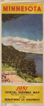
Mouse Over to See Reverse Side

|

Stats:
- Size: 38" x 32" unfolded, 4"
x 9" folded.
- Scale: 1 inch = 12 miles
- Conditions as of: January 1, 1951
- Cartographers: The H.M. Gousha Company.
- Commissioner of Highways: M.J. Hoffmann.
Comments:
- In 1951 the Department of Highways contracted with the H.M. Gousha
Company to produce the cartography for the official highway maps.
Gousha continued to produce the official highway maps until 1961. For the most part, Gousha kept the old cartographic symbols and format. However, Gousha's cartography was much finer and easier to read. This gave the maps issued from 1951 to 1961 a more modern appearance.
- The 1951 map served as a prototype for the maps issued through 1961. Differences between it and the later maps included a lack of yellow tinting on the main map, and the filling in of state and national parks.
- Gousha introduced new formats for the Twin Cites and Duluth insets, which were placed on the front side of the map. The old-style city insets on the back of the map were temporarily retained.
- The map key was moved back to its traditional place in the
upper right hand corner of the front of the map. It remained in this
position on all maps issued by Gousha through 1961.
- The french symbol and arrowhead in the upper corners of the map
remained from the previous map design. The blue and yellow borders
were modified into a diamond design.
|