 Trunk Highways of Dakota County - A History (Page 3)
>> Jump to Page: 1 | 2 | 3 | 4
Modernization: 1946-1966
Between 1946 and 1966, the Minnesota Department of Highways undertook a large number of projects to upgrade the highways in Dakota County. The projects included constructing expressways, eliminating unpaved highways, rebuilding and repaving antiquated roads, and increasing the size of the network. Last, and certainly not least, was the construction of the first Interstate Highways in Dakota County between 1959 and 1966.
>> Contents:
- Fixing the System, 1946-1953
- New Routes and Route Changes, 1950-1961
- Interstates and Expressways, 1959-1966
Fixing the System, 1946-1953
The highway projects conducted in Dakota County in the immediate post-war period eliminated glaring issues and inadequacies in the highway network that not been addressed in prior years. These included paving over and widening some stretches of the old concrete highways in use since the 1920's, as well as totally reconstructing or replacing some of the stretches of highway added in 1934.
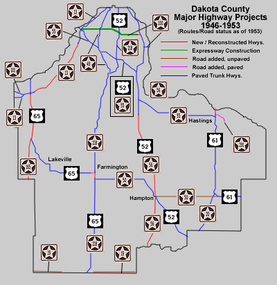
Upgrading U.S. 52 and State Highway 56, and extending State Highway 50, 1947-1950
One of the largest projects conducted in the immediate post-war period was the total replacement of the U.S. Highway 52 / State Highway 56 duplex between the junction with Highway 55 at Pine Bend and Hampton, plus the construction of a new alignment for State Highway 56 between Hampton and the Goodhue County Line at Randolph. The new grades were completed in 1947.
The new highway between Coates and Hampton was on a more easterly alignment, bypassing several sharp curves on the old road (modern County Road 81), and the town of Hampton itself. The new highway constructed for State Highway 56 ran from a new divided junction southeast of Hampton to the Cannon River, bypassing the town of Randolph. However, a bridge for the new alignment over the Cannon River was not completed until 1950. In the meantime, traffic had to be routed onto the old river crossing, with a temporary connection between Randolph and the new highway on what is now County Road 88. The U.S. 52/MN 56 duplex north of Hampton was paved in in 1949. Highway 56's new alignment was paved in 1950. The new grades and junction constructed in 1947 are on the alignments still in use by U.S. 52 and State Highway 56 today (U.S. 52 was upgraded to an expressway in the early 1960's, more on this later).
While this construction was taking place, the legislature extended Highway 50 from U.S. Highway 52 at Hampton to U.S. Highway 61 (legislative route 245) in 1948. This road was still gravel at the time, and would not be paved until the late 1950's.
The Highway 100 Expressway, 1948
 The
construction of the Highway 100 expressway between the Mendota Bridge and
South St. Paul was another project started before World War 2, but not finished
until the post-war period. In 1948, the rest of the new expressway between the junction with State
Highway 55 at the Mendota Bridge and the western end of the 1943 construction
was completed. Also completed in 1948 was an interchange with Robert Street
(then U.S. Highway 52 and State Highway 218). Dakota County's first expressway
was hindered by its poor connections on both ends (see the scan from the 1954
official highway map, left). At Highway 55, the 4 lanes of traffic had to
be reduced to two before crossing the Mendota Bridge. On the eastern end the expressway fed onto a city street in South St. Paul, taken over from the
city in 1948. To cross the Mississippi River, Highway 100 still had to duplex
with State Highway 56 on Concord Boulevard to the Inver Grove Toll Bridge,
two miles to the south. It would be another ten years before the Wakota Bridge
would finally eliminate this inadequacy.
The Farmington Bypass, 1949
Since the first highways were routed into Farmington in 1921, all routes through town had followed a convoluted series of turns on various city streets. Although the highways to both the north and south of town actually lined up exactly, a rail yard had prevented the construction of a direct connection. . Finally in 1949 the rail yard was removed, and a bypass was constructed along the east side of town. This allowed traffic on Highway 218 between Northfield and St. Paul to travel directly past Farmington for the first time. U.S. Highway 65, which entered Farmington from the south, turned off the new Highway on Elm Street (now County Road 50) to connect directly to the old highway to Lakeville and Minneapolis.
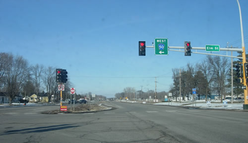
Looking north on the Farmington Bypass (now Highway 3) at Elm Street. This was the site of the junction of U.S. 65 turn-off towards Minneapolis.
Upgrading Highway 165, 1948-49
State Highway 165 had been created in 1934 as an alternate to U.S. 65 between Lakeville and Faribault, bypassing the towns of Farmington and Northfield. However, it had not been developed or paved since 1934 (at least in Dakota County), making it rather ineffective as a short cut. This was finally changed in 1948 when a new, more westerly road was constructed, bypassing the old route (Dodd Road) south of Lakeville. The new road was constructed to meet U.S. Highway 65 three miles northwest of the original junction, making the short-cut even more direct. The first mile of the new highway at the junction with U.S. 65 was built as a divided highway. The road was paved in 1949.
The upgrade of Highway 165 would eventually lead to its demise as a route. U.S. 65 would be moved to the more direct highway in 1956 after further upgrades were completed at Faribault . The alignment of the upgraded 165 would eventually become the alignment of Interstate 35 in 1966.
Rebuilding Highways 13 and 19, 1947-1948
HIghway 13 was completely rebuilt between the Mendota Bridge and Nicollet Avenue in Burnsville in 1948. The original road, in use since 1934, had been rather windy and indirect. The plans for this reconstruction were first completed in 1938, with final approval given in 1941, showing that the Department of Highways had wanted to rebuild this stretch of Highway 13 much sooner.
On Dakota County's southern border, Highway 19 was finally reconstructed and paved for the first time between 1947 and 1948. Part of this construction resulted in the realignment of Highway 19 west of the town of Northfield one mile to the north. Highway 19 now ran along Dakota County's southern border both east and west of Northfield.
Replacing the Spiral Bridge at Hastings, 1951
In 1951, a new bridge over the Mississippi River was completed at Hastings for U.S. 61, replacing the old Spiral Bridge which had been in use since 1895. The updated bridge fed traffic on directly onto Vermillion Street, bypassing the old route on 2nd (Main) Street. The original bridge was demolished shortly thereafter, a fact that is bemoaned by the residents of Hastings to this day.
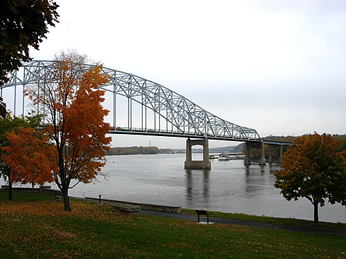
The modern Mississippi River bridge at Hastings, looking northwest.
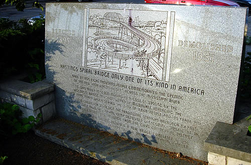
A marker now marks the location of the old spiral bridge at
Hastings. Notice the reflection of its replacement on the marker.
A new road for U.S. 65, 1953
In 1953, a new highway was constructed for U.S. 65 between the junction with State Highway 165 near Lakeville and just south of the junction with State Highway 13 in Burnsville. The new road replaced the original highway (now Burnsville Parkway and Kenwood Trail) which had been in use since 1921. The new road had a much straighter alignment, reducing the distance between the Lyndale Avenue Bridge and the Hwy 165 turn-off. Interstates 35 and 35W would eventually be built along this alignment in the 1960's.
The End of Unpaved Trunk Highways in Dakota County, 1957.
In 1957, the last gravel trunk highway in Dakota County, Highway 50 from Hampton to U.S. 61, was finally paved (according to construction records). However, Official Highway maps don't show it as paved until 1963 (I'm going to have to trust the construction record on this, as it also shows several bituminous surface repairs in practically every year between 1957 and 1963.)
>> Jump To: Fixing the System, 1946-1953 | New Routes and Route Changes, 1950-1961 | Interstates and Expressways, 1959-1966
New Routes and Route Changes, 1950-1961
 |
State Highway 49 - 1950In about 1950, State Highway 49 was extended south from its old southern terminus at Downtown St. Paul to replace State Highway 88 on Dodd Road and the Jefferson Trail.
|
 |
State Highway 291 - 1951In 1951 the state legislature authorized a series of small connecting routes to various state institutions. State Highway 291 provided a route to the State Veterans Hospital in Hastings from U.S. Highway 61. The original route was along what is now County Road 54 (10th Street and Ravenna Trail). Highway 291's route was eventually moved to a more direct alignment in the 1970's a little further to the south at 18th Street. |
The Rerouting of U.S. Highway 65 - 1956
The alignment constructed for U.S. 65 in 1953 through what is now Burnsville was designed to connect directly with the alignment constructed for State HIghway 165 in 1948. However, U.S. 65's route still turned off at the junction towards Lakeville, Farmington, and Northfield. It was not until 1956 that U.S. 65 was finally moved to the more direct route to Faribault on the future alignment of Interstate 35 (Hwy 165 was decommissioned). U.S. 65's old alignment between Farmington and Lakeville was replaced by State HIghway 50, which had actually been the original designation for this road before 1934.
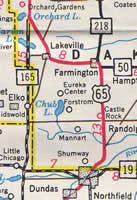

Scans from the 1956 (left) and 1957 (right) official highway maps, showing the re-routing of U.S. 65 and State HIghway 50.
 |
State Highway 36 - 1957In 1957, State Highway 36 was extended south on Cedar Avenue into Dakota County, ending at the junction with State Highway 13 in Eagan. This added the already existing Cedar Avenue bridge to the trunk highway system. Like many of the other bridges into Dakota County at the time, the old Cedar Avenue bridge could swing open to allow river traffic to pass, disrupting auto traffic in the process. |
 |
State Highway 316 - 1959In 1959 the state legislature authorized LR 316, adding the shorter route on Red Wing Boulevard between the cities of Hastings and Red Wing to the trunk highway system. This authorization may have been intended as a new and more efficient routing for U.S. Highway 61, but U.S. 61 was never realigned. Instead, the new route was designated using its authorizing route number. |
 |
State Highway 3 - 1961In 1961, State Highway 218 was redesignated State Highway 3 as part of a statewide route system overhaul. |
(note: Minnesota adopted new state highway markers in about 1954)
>> Jump To: Fixing the System, 1946-1953 | New Routes and Route Changes, 1950-1961 | Interstates and Expressways, 1959-1966
Interstates and Expressways, 1958-1966
The late 1950's saw the beginning of the construction of modern expressways and the first Interstate highways in Dakota County. By 1966, the Interstate 35/35W corridor through Lakeville and Burnsville would be complete, as well as small portions of I-35E and I-494. All of the original Interstate Highways built in Dakota County between 1959 and 1966 required the construction of new bridges over the Minnesota or Mississippi Rivers. Also of great importance was the completion of the U.S. 52 expressway to Rochester (see map below for an overview).

Construction of the U.S. 52/Highway 55/Highway 56 expressway, 1958-1966
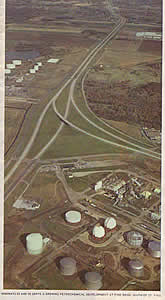
U.S. Highway 52, the primary link between the Twin Cities and Rochester, had already been upgraded a great deal in Dakota County after World War 2. The importance of this highway led to further upgrades starting in the late 1950's. In 1959, the first portion of a 4-lane expressway was completed for State Highway 55 and U.S. Highway 52 from the junction with State Highway 49 in Eagan to the south junction with Highway 55 at Pine Bend. Construction continued into the 1960's. U.S. 52 (duplexed with Highway 56) was upgraded to 4 lanes from Pine Bend to Hampton in 1962, and south to what is now County Road 86 just north of Cannon Falls in 1963. The final stage, a bypass of Cannon Falls and a new bridge over the Cannon River, was completed in 1966.
At right is the cover of the 1966 official highway map. It shows the first completed portion of the U.S. 52 expressway, looking north from the south junction with State Highway 55 at Pine Bend. The caption below the image reads: "Highways 52 and 55 serve a growing petrochemical development at Pine Bend, south of St. Paul".
Interstate 494, State Highway 110, and the Wakota Bridge
 The
first Interstate highway to be constructed in Dakota County was a
portion of Interstate 494, between the city limits of South St. Paul and Newport, including the Wakota Bridge, completed in 1959.
Although completed as an interstate highway, this project was in reality the
completion of the Highway 100 expressway across northern Dakota County. The
Wakota Bridge finally replaced the outmoded Inver Grove Toll Bridge two miles
to the south.
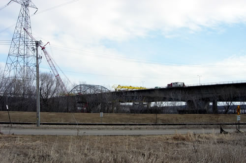
The original Wakota Bridge (the steel arch), in the process
of being replaced. Even though it was a massive improvement over the old Inver
Grove Toll Bridge when it was completed in 1959, it later become a bottleneck.
The bridge was recently demolished.

Driving west on the old Wakota Bridge. The new span can be
seen on the right.
 Highway
100 continued to duplex across the river with 494 to Washington County until
about 1965, when it was retired outside of Hennepin County. By that time, enough of the 494/694 loop had
been completed to disrupt Highway 100's old role as the Twin Cities ring route.
The remaining sections outside Hennepin County were given new numbers. The section in Dakota County became State Highway 110.
The Interstate 35/35W Corridor

 Much
like the construction of the first portion of Interstate 494, the first portion
of I-35W completed in Dakota County in 1960 was also a replacement for a river
crossing. The 35W bridge replaced the old Lyndale Avenue Bridge over the Minnesota
River, which had been built back in 1921 for old State Highway 50, later carrying U.S. 55 and lastly U.S. 65. The Lyndale
Avenue bridge, like many other older spans over the Minnesota River, was constructed
to allow for the passing of river traffic , in this case via a draw-bridge. This could
cause traffic disruption on U.S. Highway 65, the main route out of Minneapolis
to the south. In 1960, 35W was completed from the river to the junction
with State Highway 13, where a new cloverleaf interchange was constructed.
The rest of the 35W/35 corridor was not completed through Burnsville and Lakeville
until 1966.
The 35/35W corridor was constructed along, and sometimes on top of, the alignment of the old two-lane road previously in use by U.S. 65. U.S. 65 was moved onto the freeway, and remained duplexed with I-35 and I-35W until about 1980, when it was truncated at Albert Lea near the Iowa border.
Highway 13 and Highway 101 Route Changes and Upgrades
In 1966, Highway 13 was upgraded into a divided highway from 35W in Burnsville to Savage along the alignment previously marked as State Highway 101 (constructed in 1942). Highway 101 remained duplexed with 13 as far east as 35W until about 1963, when it was truncated at its west junction with Highway 13 west of Savage.
Interstate 35E, the "Highway to Nowhere"
 The
first portion of Interstate 35E was completed as far south as Highway 13 in
1965 and extended south to the Highway 110 expressway in 1966. Construction included The Lexington Bridge over the Mississippi River (recently replaced). This section
of freeway is frequently referred on other sites as the "highway to nowhere",
since it lacked connections to the north and south until the 1980's.
After 1966, Dakota County entered a lull in major highway construction. For the most part, the roads in use in 1966 would remain the primary highway network until the late 1970's, when freeway construction would begin anew.
>> Next Page - Building the Modern System, 1967-2006
>> Jump To: Fixing the System, 1946-1953 | New Routes and Route Changes, 1950-1961 | Interstates and Expressways, 1959-1966
>> back to top
>> Page Index
- Page 1 - Beginnings: Dakota County's First Trunk Highways, 1921-1934
- Page 2 - Maturity: Pre-war development and the legislative routes - 1934-1945
- Page 3 - Modernization: 1946-1966
- Page 4 - Building the Modern Highway System: 1966-Present
