
 Trunk Highways of Dakota County - A History (Page 2)
>> Jump to Page: 1 | 2 | 3 | 4
Maturity: Pre-war Development and the Legislative Routes - 1934-1945
Major legislation in 1933 added hundreds of miles of new highways the Trunk Highway System on top of the backbone of highways authorized in 1920. The new highways were added as "legislative routes" rather than constitutional routes. They could be modified, added, or deleted by legislative action. Dakota County was not left out of the action by any means. Legislative Routes 100, 101, 112, 115, 116, 117, and 194 all passed within the county lines. The Commissioner of Highways was also given the power to renumber the highway system as he saw fit. These factors resulted in the big renumbering of May 4, 1934. The U.S. routes were fully incorporated into the highway network, and many of the original state routes bit the dust.
Many of the new routes added to the system in 1934 were still relatively unimproved gravel roads, previously under county or local jurisdiction. A lack of major funds due to the Great Depression resulted in only basic temporary improvements being made to bring the new roads up to speed.
>> Contents
- The Renumbering of 1934
- Improving the System, 1936-1941
- The Inver Grove Toll Bridge
- Highway 101
- The Beginnings of Modernization: 1941-1945
The Renumbering of May 4, 1934
The map, right, shows Dakota County's trunk highways after the renumbering of May 4, 1934. The MInnesota Highway News claimed that the route changes were made in a single day. Notice how the old highway network. (highlighted in blue) still dominates the system. Also notice the cluster of already improved roads added to the system (highlighted in red) in the northern part of the county. Old State Routes 1, 3, and 53 were eliminated, as well as U.S. Highway 55. Remaining from the old system were U.S. 61 and State Highway 20, which were not modified in any way inside the county lines. U.S. Highway 65 and State Highway 50 also survived, but were heavily modified: U.S. Highway 65 was rerouted to Minneapolis rather than St. Paul, and State Highway 50 was greatly reduced in extent. Routes making their debut in Dakota County in 1934 were U.S. Highways 52 and 218, as well as State Highways 13, 19, 55, 56, 88, 100, and 165. |
 |
U.S. Routes in Dakota County, 1934:
(with authorizing constitutional (CR) and legislative routes (LR))
|
U.S. 52 (CR 50, LR 115, 116) U.S. Highway 52 was routed into Minnesota in 1934. It became the primary route from St. Paul to Rochester. It replaced State Route 20 from the Iowa border north through Rochester to Cannon Falls. U.S. 52 then replaced State Route 50 and U.S. Highway 55 on the road from Cannon Falls to Hampton. After passing through Hampton, U.S. 52 then broke from old Highway 50 onto what is now County Road 81, which was still gravel in 1934. It then traveled north to Pine Bend, where the gravel road met the concrete highway built for State Route 53 in 1933. U.S. 52 traveled on this road for a stretch before breaking off onto another gravel road (now 105th Street and Rich Valley Boulevard), which linked it to South Robert Trail. U.S. 52 then used South Robert Street the rest of the way to St. Paul. |
 |
U.S. 61 (CR 3) U.S. Highway 61 remained unchanged in the 1934 renumbering in Dakota County, permanently replacing old State Route 3. |
 |
U.S. Highway 65 (CR 1, CR 50) U.S. Highway 65 swapped roles in 1934, becoming the main southern route to Minneapolis instead of St. Paul. It permanently replaced old State Route 1 from Northfield to Farmington (it had been using this road since 1926). At Farmington, U.S. Highway 65 turned west towards Minneapolis on the road that had formerly been State Highway 50 and U.S. Highway 55. |
 |
U.S. Highway 218 (CR 1, LR 115) When U.S. Highway 65 was moved to its new route to Minneapolis, U.S. Highway 218 was extended north from its old northern terminus at Owatonna to St. Paul as a replacement. U.S. 218 duplexed with U.S. 65 for an unusually long distance from Owatonna to Farmington where it continued north on what had previously been State Highway 1 and U.S. Highway 65 to South Robert Trail, then continuing north on South Robert the rest of the way to St. Paul, duplexed with U.S. 52 north of Rich Valley Boulevard. |

State Routes in Dakota County, 1934:
 |
State Highway 13 (LR 117, 194) One of the original constitutional routes, Highway 13 had previously ended at the city of Jordan in Scott County. It was rerouted and extended north into Dakota County in 1934. Highway 13 paralleled the Minnesota and Mississippi Rivers from Savage to St Paul, serving as the capital city's new connection with southwest Minnesota. Highway 13 was only paved north of the Mendota Bridge in 1934. The remainder of the route to Savage was still gravel. |
 |
State Highway 19 (LR 100) State Highway 19 ran along Dakota County's southern border east of Northfield on its way to Cannon Falls. The road was still gravel in 1934. |
 |
State Highway 20 (CR 20) State Highway 20 was the only state highway to remain untouched in Dakota County in the 1934 renumbering, although it was replaced by U.S. 52 south of Cannon Falls. It now served as a short connecting route to Cannon Falls from U.S. 61. |
 |
State Highway 50 (CR 50) State Highway 50 had previously been the primary route out of Minneapolis to the south and east. In 1934 it was replaced by U.S. 65 northwest of Farmington, and by U.S. Highway 52 from Hampton to Cannon Falls. The only remaining portion was the short segment linking the towns of Farmington and Hampton. |
 |
State Highway 55 (CR 53, LR 116) State Highway 55 was the new route from Minneapolis to Hastings via the Mendota Bridge, as well as Minneapolis's primary connection with the other highways to southeastern Minnesota. Highway 55 was routed along the concrete road built in the 1920's from the Mendota Bridge to old Highway 1 in what was then Egan township. To get to Hastings, Highway 55 originally had to use a temporary route along old Route 1 (modern Highway 149), Rich Valley Boulevard, and 105th Street to old State Highway 53 at Pine Bend. State Highway 55 then replaced State Highway 53 as the designation for the highway between Pine Bend and Hastings. |
 |
State Highway 56 (CR 53, LR 112, 116) One of the original constitutional routes, State Highway 56 was extended north into Dakota County in 1934, crossing the county line at the Cannon River south of the town of Randolph. It continued north on gravel roads (modern County Roads 83 and 47) to U.S. Highway 52 at Hampton. It then duplexed with U.S. 52 north from Hampton through Coates to the junction with State Highway 55 at Pine Bend. State Highway 56 then multiplexed with U.S. 52 and State Highway 55 on what had previously been State Highway 53 until Highways 52 and 55 branched off on 105th Street. State Highway 56 then continued north, replacing State Highway 53 on Concord Boulevard through South St. Paul. |
 |
State Highway 88 (CR 1) State Highway 88 was introduced in 1934 as the replacement designation for old State Route 1 from South Robert Trail to St. Paul. |
 |
State Highway 100 (LR 116, 117) Highway 100 was introduced in 1934 as the Twin Cities circle route, although it didn't quite achieve this goal for several years. It entered Dakota County with State Highway 55 on the Mendota Bridge. It then used the already paved Mendota Road and Southview Boulevard to South St. Paul, temporarily coming to an end at State Highway 56 (Concord Boulevard). |
 |
State Highway 165 (LR 101) State Highway 165 was introduced in 1934 as an alternate to U.S. Highway 65 between Lakeville and Faribault, bypassing the towns of Farmington and Northfield on a more westerly alignment. Highway 165 originally used what is now Dodd Road (County Road 9), which was still gravel in 1934. |
May, 1935 Route Revisions
 In
May, 1935 the Minnesota Department of Highways made a series of revisions
to the route system created in 1934. The revisions were all refinements to
the U.S. Highway network within the state as mandated by the AASHO. Some of
the U.S. route extensions were deemed unnecessary. U.S. 218 was truncated once
again at Owatonna. Consequently, the 1934 extension of U.S. 218
to St. Paul reverted to a state route with the same number. U.S.
Highway 218 in Dakota County was now State Highway 218.
In
May, 1935 the Minnesota Department of Highways made a series of revisions
to the route system created in 1934. The revisions were all refinements to
the U.S. Highway network within the state as mandated by the AASHO. Some of
the U.S. route extensions were deemed unnecessary. U.S. 218 was truncated once
again at Owatonna. Consequently, the 1934 extension of U.S. 218
to St. Paul reverted to a state route with the same number. U.S.
Highway 218 in Dakota County was now State Highway 218.
>> Jump to: Renumbering of 1934 | Improving the System, 1936-1941 |The Inver Grove Toll Bridge | Highway 101 | Beginnings of Modernization: 1941-1945
Improving the Expanded Trunk Highway System, 1936-1941
The additional roads added to the trunk highway system in 1934 in Dakota County totaled up to about 63.44 miles (using mileage figures from the construction project log record), a nearly 60 percent increase! Out of the 63 additional miles, only about 24 miles, or a little over a third, was already paved (nearly all of this mileage was in the northern third of the county). Improvements to the expanded highway network were limited at first to bituminous surfacing of the existing roads and the addition of gravel shoulders for concrete highways built before 1934. Only in a few circumstances were new highways built. More major construction would have to wait until after World War 2.
The most glaring deficiency in the new network was the lack of a direct link for Highway 55 from the junction with Dodd Road (then Highway 88, now Highway 149) to Pine Bend, leaving the city of Minneapolis without a good connection to U.S. 52 and Rochester. A temporary route was in use, utilizing part of State Route 88 , as well as Rich Valley Boulevard and 105th Street. U.S. Highway 52 was also using this temporary route at the time to connect to South Robert Trail. In 1936, a new grade was completed for U.S. 52 and State Highway 55 (it was bituminous surfaced in 1937). This new highway, known as Courthouse Boulevard, provided the much needed connection.
Bituminous surfacing was undertaken on the more important highways that were still gravel when added in 1934. Highway 13 was the first to be fully bituminous surfaced south of the Mendota Bridge to Scott County in 1936. The U.S. 52 and State Highway 56 duplex between Hampton and Pine Bend was bituminous surfaced in 1938, eliminating the last gravel stretch on the main route to Rochester. Highway 56 was surfaced in the town of Randolph in 1941. The rest of Highways 56, 165, and 19 in the southern most part of the county would not be paved or improved until after World War 2.
>> Jump to: Renumbering of 1934 | Improving the System, 1936-1941 |The Inver Grove Toll Bridge | Highway 101 | Beginnings of Modernization: 1941-1945
The Inver Grove Toll Bridge
In 1938, the Department of Highways took jurisdiction over the Inver Grove Toll Bridge across the Mississippi River from Dakota County to St. Paul Park to eliminate a gap in State Highway 100. Highway 100 was extended south from its old eastern terminus at Grand and Concord in downtown South St. Paul down Concord Boulevard to 66th Street in Inver Grove, which provided the final connection to the bridge. The unusual bridge was a double decker, with a railroad trestle above a lower deck used by automobiles. The bridge was also able to swing open for river traffic.

The old Highway 100 bridge still survives today, but has been closed, and the swing section permanently opened. Legislation was proposed in 2005 to provide funding to demolish the Washington County side of the old bridge, but the provision was removed in the final version of the bonding bill. The Washington County side collapsed on its own in late 2008.
>> Jump to: Renumbering of 1934 | Improving the System, 1936-1941 |The Inver Grove Toll Bridge | Highway 101 | Beginnings of Modernization: 1941-1945
Highway 101
 Between
1939 and 1941 a new road was constructed for State Highway 101 from Shakopee
to State Highway 13 in what is now Burnsville. Highway 101 had formerly used a more southerly alignment, ending at Highway 13 in Scott County south of
Savage. The new road extended further east, bringing Highway 101 into Dakota
County in 1941. The new road was paved in 1942.
Between
1939 and 1941 a new road was constructed for State Highway 101 from Shakopee
to State Highway 13 in what is now Burnsville. Highway 101 had formerly used a more southerly alignment, ending at Highway 13 in Scott County south of
Savage. The new road extended further east, bringing Highway 101 into Dakota
County in 1941. The new road was paved in 1942.


There seems to have been some confusion at the Department of Highways about what route would use the new road (see scans from the 1942 (left) and 1946 (right) official highway maps above. The 1942 map erroneously shows Highway 13 using the new highway in 1942. The 1946 map corrects this, showing 101 and 13 coming together in Burnsville.
>> Jump to: Renumbering of 1934 | Improving the System, 1936-1941 |The Inver Grove Toll Bridge | Highway 101 | Beginnings of Modernization: 1941-1945

The trunk highway network in Dakota County as seen on the 1942 official
highway map.
Beginnings of Modernization: 1941-1945
In the early 1940's, the Department of Highways started to undertake projects in Dakota County to modernize the highway system to a greater degree. The early 1940's and war-time would see the construction of Dakota's County's first modern interchanges, and the beginning of construction on its first expressway.
Two interchanges were constructed on the Highway 55 corridor in the early 40's to improve the main road into Minneapolis. In 1941, Dakota County's first cloverleaf interchange was completed at the junction of Courthouse Boulevard and South Robert Trail. This was the primary meeting point of the main highways to Minneapolis (Highway 55), and St. Paul (U.S. 52 and Highway 218).
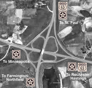
The cloverleaf interchange of South Robert Trail with
Courthouse
Boulevard from a 1947 aerial photograph.
In 1943 a new divided interchange was constructed for the junction of State Highway 55 and 88 (now the junction of Highways 55 and 149) in Eagan, just a couple of miles northwest of the cloverleaf interchange built in 1941. The existing roads meeting at the junction had been built in a piecemeal fashion, making the junction awkward for through traffic on 55. The original road (now Highway 88, formerly Highway 1), ran north/south through the interchange. The road to the west towards the Mendota Bridge had been built in the mid-twenties, and Courthouse Boulevard to the east had been constructed in 1936. The 1943 construction added a new southbound/eastbound lane to streamline the traffic flow, although there were still several points where traffic crossed, making this junction horribly deficient and dangerous by today's standards (in my opinion).

An aerial photo from 1947 shows the junction built in 1947.
The lighter roads are from the 1943 construction project. The original road,
used originally as State Highway 1, runs north/south through the photo, and
is darker in color.
The beginnings of two other major projects also occurred in 1943, neither of which would be fully complete until after WW2. The first project was the construction of an improved highway for U.S. 52 between Pine Bend and Hampton. Only the section o between Pine Bend and modern County Road 42 was replaced with a new concrete surfaced highway. This first phase of the construction may have been rushed due to the location of the Gopher Ammunition Plant nearby, which would have resulted in heavier truck traffic on U.S. 52, requiring a road that could withstand more punishment.

The ruins of the Gopher Ammunition Plant, as seen from modern
U.S. Highway 52 north of Coates.
The other project was the construction of the Highway 100 expressway between the Mendota Bridge and Newport. The first phase of the expressway was graded and graveled from Southview Boulevard to the city limits of South St. Paul in 1943. This new highway would not officially be Highway 100 until 1948. Maps from 1946 to 1948 show the uncompleted highway as "Alt. 100".

An aerial photo from 1947, showing the incomplete expressway's western end.

A scan of the South St. Paul inset from the 1946 official highway map, showing
the new alignment of Highway 100 as "alt" 100 (look in the lower
left corner).

The above diagram summarizes the major highway developments
between 1934 and 1945.
>> Next Page - Modernization: 1946-1966
>> Jump to: Renumbering of 1934 | Improving the System, 1936-1941 |The Inver Grove Toll Bridge | Highway 101 | Beginnings of Modernization: 1941-1945
>> back to top
>> Page Index
- Page 1 - Beginnings: Dakota County's First Trunk Highways, 1921-1934
- Page 2 - Maturity: Pre-war development and the legislative routes - 1934-1945
- Page 3 - Modernization: 1946-1966
- Page 4 - Building the Modern Highway System: 1966-Present