Two more articles on historic alignments of U.S. 61 just west of Duluth on the Thompson Hill have been added!
Old Hwy 61 and Thompson Hill Road
Old Hwy 61 at the Carlton/St. Louis County Line
Two more articles on historic alignments of U.S. 61 just west of Duluth on the Thompson Hill have been added!
Old Hwy 61 and Thompson Hill Road
Old Hwy 61 at the Carlton/St. Louis County Line
I recently won this little gem on ebay. Its the first photographic proof I’ve seen that the U.S. routes shields shared the same posts as the state route shields before 1934. This photo had to have been taken at some point between 1926 and 1934 on the highway between La Crosse and St. Paul.

Paul R has sent in a set of great photos of some old alignments along what is now U.S. 10 in northern Minnesota between the towns of Hawley and Audubon.
First a little background. The road between Detroit Lakes and Moorhead was still gravel back in 1921 when it was added to the trunk highway system as part of Constitutional Route 2. Prior to that it had been marked as three motor trails: The Minnesota Scenic Highway, The Duluth-Fargo Highway, and the Mississippi River Scenic Highway. In late 1926 the road also became part of U.S. 10N (U.S. 10 originally had two branches between St. Cloud and Fargo, a northern one along today’s familiar route, and a southern one along what is now I-94).Â
Between 1927 and 1929 the old gravel road between Moorhead and Detroit Lakes was replaced by a 20-foot wide concrete highway. In 1934 both U.S. 10N and Constitutional Route 2 were retired, and replaced by plain old U.S. 10. The first concrete road between Hawley and Audubon served until 1957, when it was replaced by the construction of the current divided highway.
The map below shows the alignment of the original gravel road in purple, and the first paved road where it deviated from the modern highway in red. Nearly all of the original gravel road still survives today. On the other hand, only two short sections of the early concrete highway have survived, and are now used as service drives.
View Deadpioneer’s Historic Minnesota Highways Blog Map in a larger map
The old gravel road ran east from Hawley along Junction Avenue, eventually merging onto what is now Clay County Road 115, which becomes Becker County Road 102 at the county line. The old road then continued east to Lake Park, turned south through town, and turned east again onto a road that passed south of Bower Lake. Sadly, several sections of the road south and east of Lake Park have been lost to time.
We begin our journey in the town of Hawley (to follow along, you can zoom into map above, or open it in a new window).


Today we have another set of photos from “Highway Explorer”, this time of a stretch of old highway in the northeastern corner of Rice County. This road, now labeled on maps as Albany Avenue, was once part of State Highway 165. However, its history goes back a bit further. (See below for a map of the south end of the old alignment).
The first road in this area was the historic Dodd Road, a path blazed between St. Paul and St. Peter in the mid 1850’s. By the early 1920’s, the stretch of Dodd Road  in northeast Rice County had ceased to be an important long-distance route. A 1921 auto trails map doesn’t even show it. Construction records show that the road was graveled (and presumably graded) as a county job in 1924. Construction plans show the road as “State Road 25”, which in today’s terms would be a County State Aid Highway. The road was eventually added to the trunk highway system in 1934 as part of the new State Highway 165, a route connecting Faribault and Lakeville as an alternate to U.S. 65, bypassing Northfield.
What is now Albany Avenue remained in use until 1947, when a new grade was constructed just to the east, leaving it behind as a local road, shown on later construction plans as County Road 98.  The new grade was paved in 1949, and eventually became U.S. 65 in 1956.  In 1964, I-35 was constructed just to the west. The bit of the south end of Albany Avenue was destroyed by the new freeway.
Today, the old highway remains gravel, just as it was back in 1924.  Bridge #3978, a 20 foot concrete slab structure constructed in 1923 by the Department of Highways over Chub Creek, still survives today. The old road also passes by an historic church and through the unincorporated town of Hazelwood. It is now accessible at both ends via Rice County Road 46, which now occupies the old two-lane alignment of U.S. 65.


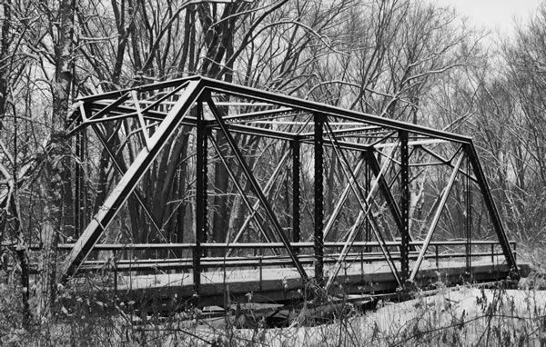
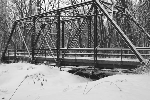
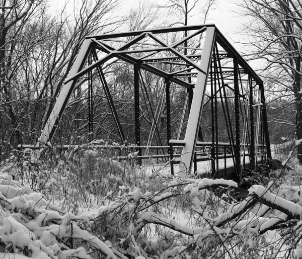
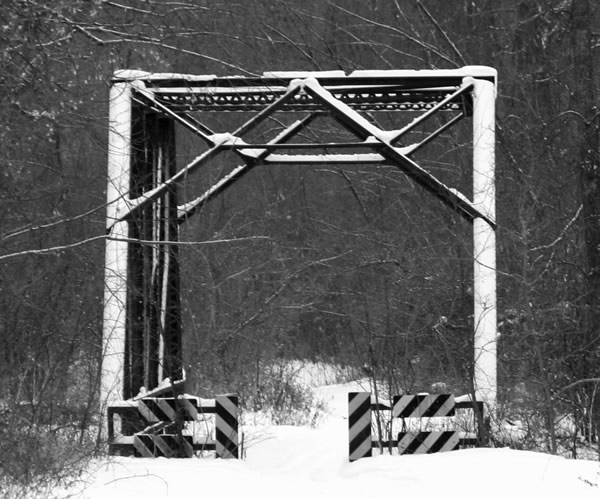
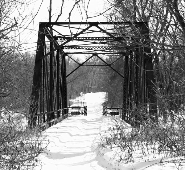
Kim Mensinger has sent in some nice photos of a couple of  the historic bridges on the Cannon Bottom Road, just west of Red Wing, which was bypassed in 1931 (it was once part of U.S. 61 and Constitutional Route 3). These bridges are scheduled to be demolished in the next few years. For more info on this historic highway, see the article here (from my U.S. 61 project, pops in a new window/tab).


“Highway Explorer” has found and photographed three long lost sections of U.S. 14 between the towns of Winona and Stockton in southeastern Minnesota, complete with original pavement and retaining walls! These sections were once part of one of Minnesota’s first concrete highways, constructed by Winona County between 1914 and 1915. This early highway was actually only half paved: one lane was made up of a narrow 8 foot wide strip of concrete pavement, while the other was given a standard gravel surface. The old road hugged the bluff line closely and made many dangerous sharp turns above steep wooded cliffs and hills.
The road between Winona and Stockton became part the trunk highway system in 1921 as part of Constitutional Route 7. It later became part of U.S. 14 in 1926 (the two routes were marked together until 1934).  Decorative stone retaining walls were constructed in two locations on the hill in 1921 to improve safety, along with some standard wood guard rails (sections of both stone walls survive today, read on for pictures/ details). The original paved road remained in use until 1932, when the Department of Highways constructed a new grade along the alignment still in use today, which was designed to lessen the severity of the sharpest turns and reduce the steepness of the grade.
The first section we have photos for is just east of the scenic overlook near the top of the Stockton Hill, east of a deep gully on the north side of the highway. (Click here to see a birds eye view of the location, the stone wall is just visible.) The old road is only accessible by foot; blasting of the cliff face just to the east has disconnected the old road from the new highway.


The next section is just above, and to the west of the scenic overlook at the top of Stockton Hill. It can be accessed on foot via an entrance on Quarry Hill Road (Rural Route 3), just northeast of the monastery. This surviving section is much longer, extending east into the woods until it ends at a sheer cliff, blasted for construction of the modern highway. (Click here for a birds eye view).


The third segment was once known as the “Devil’s Elbow”, which was an incredibly sharp turn on the western slope of the Stockton Hill. Click here to see it in bird’s eye view). This was the second location where stone retaining walls were constructed in 1921. This curve was also a favorite of photographers of the time.


Thanks to “Highway Explorer” for these great finds!

Comments? Corrections? Questions?: Email Me At: andrew@deadpioneer.com
All content © Andrew Munsch