
Home >> Projects >> U.S. 61 >> Modern Highway Photo Galleries
 Modern Highway Photos: La Crosse to Winona
October, 2007 (Page 8)
>> Jump to Page: 1 | 2 | 3 | 4 | 5 | 6 | 7 | 8 | 9 | 10

Back on the main highway, heading north from Homer to Winona. The top of Sugarloaf
Hill is just visible in the center of the photo.

Entering Winona. Sugar Loaf Hill is on the left.
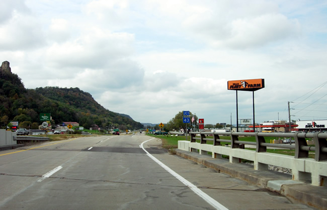
Approaching the junction with State Highway 43 on the bridge over Burns Creek.
The area around the junction of U.S. 61/U.S. 14 with Highway 43 is one of
Winona's busiest retail districts.

Approaching the junction with Highway 43. Note the sign indicating State Highway
43 as the route to Wisconsin.

Signage at the junction with State Highway 43. Highway 43 is actually the
old alignment U.S. 61 used before the construction of the modern four lane
highway in the late 1950's. Highway 43 itself is a remnant of Minnesota's
original constitutional route system. It was first marked as the route from
Winona to Rushford in 1921.

Looking south across U.S. 61/U.S. 14 towards Sugar Loaf Hill from the Dairy
Queen at the northwest corner of the junction with Highway 43.
>> Next Page
>> Page Index
- Page 1 - Southbound on I-90
- Page 2 - Southbound, La Crescent and the Jct. with State Hwy. 16
- Page 3 - Southbound, From La Crescent to the Wisconsin State Line
- Page 4 - Northbound, From the Wisconsin State Line to La Crescent
- Page 5 - Northbound, At the South Jct. with I-90 Near Dresbach
- Page 6 - Northbound, From Dakota to La Moille
- Page 7 - Northbound, From La Moille to Homer
- Page 8 - Northbound, From Homer to the Jct. with State Hwy. 43 at Winona
- Page 9 - At Winona, From the Jct. with State Hwy. 43 to Gilmore Avenue
- Page 10 - From the Jct. with U.S. 14 at Winona to County Road 32 at Goodview
>> Back to the Photo Gallery Index
>> back to top