
>> Articles
Hey, where'd 55 go?
The Last Trunk
Highways in Downtown Minneapolis
Like any red blooded Minnepolitan, I like to take an occasional cruise down Hiawatha Avenue in south Minneapolis to experience the joy of stopping at lights that make you wait for a whole five minutes while no traffic passes through the intersection. But I digress. This article isn't about the crappy stoplights on Hiawatha. This little tome is about what happened to State Highway 55's route through downtown Minneapolis. The story begins one sunday morning this spring when I was driving towards downtown (and home) on westbound Highway 55/Hiawatha. Just before I hit the exit for 35W north, I noticed that there were no signs indicating where traffic continuing on 55 should go, since it certainly doesn't end at downtown, actually ending at the North Dakota border south of Breckenridge after a long journey through west-central Minnesota.
According to the 2005/06 official highway map, westbound 55 enters downtown via ramps feeding traffic from Hiawatha Avenue onto 7th Street South. The next time I was driving on Hiawatha, I took a closer look at the 7th Street exit sign.
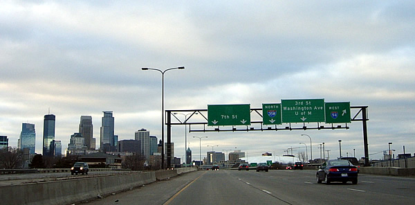
Wow, look at that huge blank above "7th St" on the sign on the left. Could there have been a "55" state highway marker there at some point? You can't see it in the photo above, but there is actually a grimy stain on the "7th St" exit sign in the shape of a state highway marker, so the old markers have definitely been removed. Could this mean that MNDOT is eliminating the last trunk highways in downtown Minneapolis?
Evidence straight from MNDOT
To answer this, I decided to take a look at MNDOT's highway log point guide, and sure enough, there's a "gap in roadway" in downtown. Highway 55 now technically terminates at the end of the 7th Street ramp on the southeast side of downtown, and at I-94/Lyndale avenue on the northwest side of downtown. MNDOT now counts the old alignment of 55 as trunk highway 955A (should be unmarked), which basically slates it to be removed from the highway system. This made me wonder if the same thing was happening to the only other trunk highway still on city streets in downtown Minneapolis, State Highway 65. Just as suspected, the Highway 65 markers have been removed from exit signs south of downtown on I-35W northbound, (picture forthcoming). The log point guide also indicates a "gap in roadway" for 65 in downtown (with the exit ramps to and from I-35W on the south side of downtown still counted as part of the highway). Highway 65 now technically starts at the intersection of 3rd Avenue and Washington Avenue in downtown in front of the Milwaukee Road Depot. The remainder of 65 in downtown is now counted as 965A.
Why would anyone want to drive through downtown anyway?
 It
seems odd that any through trunk highway route would make you navigate the
streets of downtown MInneapolis instead of just zooming (well, not at rush
hour anyway) around downtown on I-94 or I-35W. In a way, Highways 55 and
65 are remnants of the days when trunk highways on city streets were the
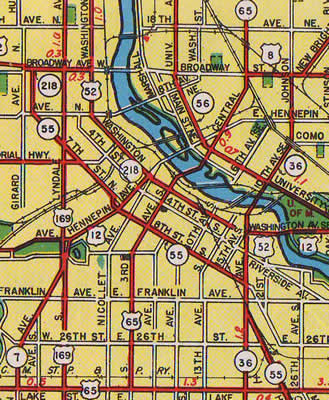
rule rather then the exception (see the map at right, from the 1950 official
highway map). Before Interstates 94 and 35W were constructed around downtown
Minneapolis in the mid to late sixties (with 94 north and west of downtown
not being finished until the mid eighties), all through routes were stuck
navigating city streets. Washington Avenue was the main drag, being part
of both US routes 52 and 12. US 52, US 12, US 65, and US 8 all came together
at the intersection of 3rd Avenue and Washington Avenue next to the Milwaukee
Road depot. Elsewhere in the city center, US 169 ran north/south on Lyndale
Avenue on the west side of downtown, while State Highway 36 used Cedar on
the east. In addition, Highway 7 once started in front of the Basilica on
Hennepin Avenue. In contrast to the old jungle of routes, today both US
52 and US 12 are routed onto I-94 (US 52 isn't even signed, and US 12 doesn't
really show up again until the western end of I-394). Most of the other
old routes don't even make it into Minneapolis. US 8 ends at I-35 near Forest
Lake, and US 65 ends way down at Albert Lea. Highway 7 now starts at Highway
100 in St. Louis Park, and 36 ends at its junction with I-35W in Roseville.
All of the other routes are now gone from the downtown landscape. State
Highways 55 and 65 are the only routes left.
It
seems odd that any through trunk highway route would make you navigate the
streets of downtown MInneapolis instead of just zooming (well, not at rush
hour anyway) around downtown on I-94 or I-35W. In a way, Highways 55 and
65 are remnants of the days when trunk highways on city streets were the
rule rather then the exception (see the map at right, from the 1950 official
highway map). Before Interstates 94 and 35W were constructed around downtown
Minneapolis in the mid to late sixties (with 94 north and west of downtown
not being finished until the mid eighties), all through routes were stuck
navigating city streets. Washington Avenue was the main drag, being part
of both US routes 52 and 12. US 52, US 12, US 65, and US 8 all came together
at the intersection of 3rd Avenue and Washington Avenue next to the Milwaukee
Road depot. Elsewhere in the city center, US 169 ran north/south on Lyndale
Avenue on the west side of downtown, while State Highway 36 used Cedar on
the east. In addition, Highway 7 once started in front of the Basilica on
Hennepin Avenue. In contrast to the old jungle of routes, today both US
52 and US 12 are routed onto I-94 (US 52 isn't even signed, and US 12 doesn't
really show up again until the western end of I-394). Most of the other
old routes don't even make it into Minneapolis. US 8 ends at I-35 near Forest
Lake, and US 65 ends way down at Albert Lea. Highway 7 now starts at Highway
100 in St. Louis Park, and 36 ends at its junction with I-35W in Roseville.
All of the other routes are now gone from the downtown landscape. State
Highways 55 and 65 are the only routes left.
Highway 55
Highway 55 in downtown Minneapolis acts as an east/west axis via 7th Street (westbound), and 10th Street, 5th Avenue, and 8th Street (eastbound). Instead of feeding traffic onto or from 35W or 94 it is entirely self serving. On the east, 55 feeds onto the newly reconstructed Hiawatha Avenue corridor, and on the west onto the Olson Memorial Highway to Golden Valley.
State Route 55 was first laid out in 1934 as a long east/west radial, starting at Hastings in Dakota County on the south and east, and ending at the North Dakota border south of Breckenridge on the west. 55 has in a way always been two highways. The highway southeast of Minneapolis serves as a short route to Hastings and a connector to other routes into the southeastern part of Minnesota and Wisconsin. 55 west of Minneapolis travels roughly parallel (and south) of modern Interstate 94, connecting the Twin Cities to towns in west central Minnesota such as Buffalo, Paynesville, Glenwood, and Elbow Lake.
Originally, 55 was routed onto 8th Street through downtown. When one-way streets were introduced to Minneapolis, 7th Street became westbound 55, and 8th became the eastbound route. When the I-94/35W interchange was built southeast of downtown in the mid-sixties, ramps were built to carry 55 over the new freeways and onto the old routes on 7th and 8th streets. 7th and 8th merged on the west side of downtown, carrying 55 onto the Olson Memorial Highway. This route remained pretty much constant until the completion of the huge commuter parking ramps on the west side of downtown in conjunction with the completion of I-394. At this point, eastbound 55 was moved onto 10th Street South, using 5th Avenue to reconnect to old eastbound route on 8th Street and the ramps onto Hiawatha Avenue. This is the route still shown on the 2005/06 official highway maps.
Highway 65
Highway 65 in downtown Minneapolis acts as the primary north/south feeder for traffic coming into downtown from northbound 35W, and the primary feeder into southbound I-35W from downtown, utilizing 4th and 5th Avenues.
State highway 65's number stems from when US Route 65 was still the major route between Minneapolis and southern Minnesota before the construction of Interstate 35. US 65 was routed into downtown Minneapolis in 1934. The department of Highways assumed that they could continue the US highway designation further north into far northern Minnesota. In 1935, it was decided that the "US" designation should end at 3rd and Washington at the junction with US routes 52, 8, and 12. Instead of getting rid of the number completely, the highway department made the northern part of US 65 State Route 65 instead.
Originally, US Route 65 entered downtown Minneapolis from the south on 3rd Avenue, which continued straight north to the 3rd Avenue bridge at the Mississippi River. When Interstate 35 was constructed in the mid-sixties, the primary downtown exit was designed to feed traffic onto 5th Avenue (northbound), and accept traffic from 4th Avenue (southbound) instead of the old route on 3rd. US 65 continued to be routed on I-35W and into downtown Minneapolis until about 1980, when it was truncated at Albert Lea. At this point, State Route 65 was extended south from 3rd and Washington on various city streets in order to connect to the 4th and 5th Avenue feeders onto I-35W.
So, what's left of highways 55 and 65?
Although the route signs have been removed from the entrances to downtown, most of the old route markers are still posted on the downtown streets. MNDOT has not yet marked an actual through route for Highway 55 yet (which I assume will be entirely on I-94 around the south side of downtown). Highway 65 will most likely continue to be truncated further and further north up Central Avenue, probably finally ending at I-694 in Fridley as MNDOT gets rid of extra highway mileage.
Highway 55 westbound

Right after you get off the 7th Street ramp, 55 magically shows up again (at 7th and 13th).

Entering the concrete jungle on 7th Street.
Highway 55 Eastbound

Looking east at the junction of Highway 55 and Interstate 94. Notice the large blank space above the "Olson Hwy" sign where the 55 marker used to be. There is no obvious indication as to where 55 is routed.

Good thing I looked to the right, or I would have missed this. Apparently, 55 IS routed onto I-94. This is the only actual indicator I have seen that seems to show what MNDOT intends to eventually do to 55. Funny how this sign isn't meant for traffic on eastbound 55.

Continuing east on what you could consider "old 55". Another erased 55 sign. In fact, all eastbound 55 signage has disappeared west of 5th Avenue. This is the one stretch of old highway in downtown that MNDOT has actually removed the route indicators from as of May 2006.

Old eastbound 55 at the massive parking ramps built in the early 90's. Eastbound 55 was rerouted off of 8th Street (west of 5th Avenue) onto 10th Street to circumvent these huge new structures, and possibly to feed traffic to the entrance ramps to southbound I-35W at 10th Street and 4th Avenue.

After a short duplex with old Highway 65 on 5th Avenue, 55 once again hops onto 8th Street on its way to the ramps feeding onto Hiawatha Avenue. The bums at the charity place across the street thought I was getting evidence to fight a ticket from the red-light camera at the intersection of 5th Ave and 8th Street. "I'll testify for ya!" the guy on the sidewalk is yelling.
Highway 65 Southbound

Looking south on Central Avenue, just south of the intersection with University Avenue (and the southern terminus of State Highway 47 by the way). You can see the milling district in the distance.

On the historic 3rd Avenue Bridge, looking south. This bridge was also part of US Route 8 for many years. Notice the new condo construction underway.

Looking south at 3rd Avenue and Washington in front of the old Milwaukee Road Depot. This was once the meeting point of 4 US routes (8, 12, 52, and 65). The little 35W shield is actually bolted as an independent piece onto the sign. Southbound 65 turns east here towards 4th Avenue.

Looking east on Washington Avenue just before 65's turn onto 4th Avenue towards 35W. The old Milwaukee Depot's train shed (now a skating rink) is on the left.

Looking south on 4th Avenue at 8th Street. Hmmm. Interesting. A sign indicating the one block connection to eastbound 55.

The primary on-ramp to southbound 35W from 4th Avenue (also the junction with eastbound 55, though this is no longer indicated).
Highway 65 Northbound

Looking north on 5th Avenue from 10th Street. At this point, signage for eastbound 55 reappears.

Looking north at 5th Avenue and Washington. This is the last northbound 65 signage until Central Avenue SE and 5th Street SE on the other side of the river. You can see the 3rd Avenue bridge in the distance.

At 3rd Avenue and Washington, looking west. The broken square sign may be all that's left of the northbound 65 signage directing traffic to the 3rd Avenue bridge.